From cirrus wisps to cumulonimbus giants, Earth’s sky is a precisely ordered world that science has only begun to fully decode.
By Cecilia Chepkong’a
The sky above is not a single canvas but a structured atmosphere divided into distinct layers, each hosting cloud formations that govern weather, climate and the rhythms of daily life.
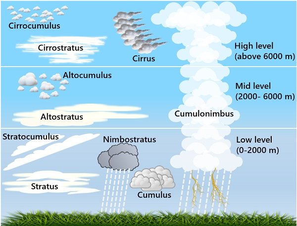
At the highest level, between 20,000 feet and beyond, cirrus, cirrostratus and cirrocumulus clouds dominate. Cirrus clouds are thin, wind-stretched wisps of ice crystals. Cirrostratus forms translucent veils that cast halos around the sun and moon. Cirrocumulus appears in small, fish-scale sheets — delicate and fleeting.
The middle layer, between 6,500 and 20,000 feet, holds altocumulus, altostratus and nimbostratus clouds. Altocumulus resembles scattered flocks of sheep and signals humid but fair conditions. Altostratus spreads as a grey sheet across the entire sky. Nimbostratus is the brooding dark mass that delivers steady, prolonged rainfall.
At low level, below 6,500 feet, stratus, cumulus, stratocumulus and cumulonimbus clouds form. Stratus is lifted fog producing light drizzle. Cumulus are the familiar white, flat-based puffs of fair weather. Stratocumulus are lumpy, grey and largely benign. Cumulonimbus, the most dramatic of all, towers from low dark bases and unleashes heavy rain, lightning and storms.
Each layer is a chapter in a larger story — one the sky writes and rewrites daily, indifferent to whether we are paying attention.
Similar Posts by The Mt Kenya Times:
- Who will carry the students’ voice? Laikipia University prepares for November 18 elections
- Cultural features of the concept of “Anger” in French and Uzbek
- Carrick on the edge as Manchester United consider managerial change
- Court steps in as FKF leadership war threatens Kenya’s AFCON 2027 dream
- Emirates expands Premium Economy and winter sun routes across Europe